I designed a corner module set based on Santa Ana Street and Olive in Anahiem, CA. There were warehouses and a couple of packing houses on Santa Ana Street, and a lumber yard on the corner (still there, but serviced by trucks now.) The area has been redeveloped over the years, so many of the warehouses are also gone.
![12.0x12.0_90-degree_street-running_lead8--36-inch_radius 12.0x12.0_90-degree_street-running_lead8--36-inch_radius](https://ogrforum.com/fileSendAction/fcType/0/fcOid/18746737995479089/filePointer/18746737995769737/fodoid/18746737995769726/imageType/MEDIUM/inlineImage/true/12.0x12.0_90-degree_street-running_lead8--36-inch_radius.bmp)
Here are some others from other parts of the US:
![7879_050403_f 7879_050403_f](https://ogrforum.com/fileSendAction/fcType/0/fcOid/18746737995479089/filePointer/18746737995769738/fodoid/18746737995769727/imageType/MEDIUM/inlineImage/true/7879_050403_f.jpg)
![cp-newalbany cp-newalbany](https://ogrforum.com/fileSendAction/fcType/0/fcOid/18746737995479089/filePointer/18746737995769740/fodoid/18746737995769728/imageType/MEDIUM/inlineImage/true/cp-newalbany.jpg)
![mdmiddmwebhome mdmiddmwebhome](https://ogrforum.com/fileSendAction/fcType/0/fcOid/18746737995479089/filePointer/18746737995769741/fodoid/18746737995769729/imageType/MEDIUM/inlineImage/true/mdmiddmwebhome.jpg)
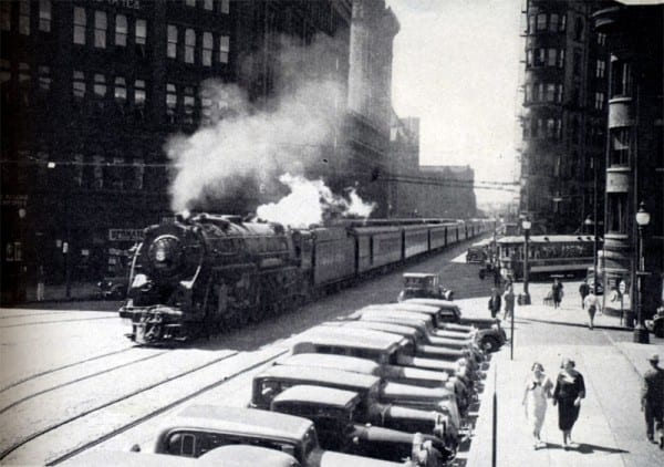
Median street running like this one would be easier to implement in a modeling context because you don't have to bury track in the pavement. Vermont Avenue between Redondo Beach Blvd. and Gardena Blvd. in Gardena, California and old Alameda Street running through Compton and Los Angeles are other examples.
![NS_C40-9W_9323_003 NS_C40-9W_9323_003](https://ogrforum.com/fileSendAction/fcType/0/fcOid/18746737995479089/filePointer/18746737995769742/fodoid/18746737995769730/imageType/MEDIUM/inlineImage/true/NS_C40-9W_9323_003.jpg)
![ns9237brownsvillepa0503 ns9237brownsvillepa0503](https://ogrforum.com/fileSendAction/fcType/0/fcOid/18746737995479089/filePointer/18746737995769743/fodoid/18746737995769731/imageType/MEDIUM/inlineImage/true/ns9237brownsvillepa0503.jpg)
![swp2002tavern0503 swp2002tavern0503](https://ogrforum.com/fileSendAction/fcType/0/fcOid/18746737995479089/filePointer/18746737995769744/fodoid/18746737995769732/imageType/MEDIUM/inlineImage/true/swp2002tavern0503.jpg)
![UP4993 UP4993](https://ogrforum.com/fileSendAction/fcType/0/fcOid/18746737995479089/filePointer/18746737995769745/fodoid/18746737995769733/imageType/MEDIUM/inlineImage/true/UP4993.jpg)
Another one which gets a lot of YouTube coverage is "Jack London Square" in Oakland. It's a three-track paved right-of-way with [I believe] a lane or two of vehicle traffic. Good for train watching, but not something I'd want to model as it's not much more than a very wide alley for trains. Historically, it was quite different because you had multiple roads traveling through the area.
Check out www.historicaerials.com once you track down the areas and you can see older coverage. On YouTube, search "Street Trackage" or "Railroad Street Running" and you should get some good hits.