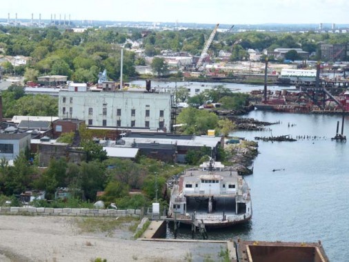
This was the last of the 69 street ferries It saw service as the Governors Island ferry too. It is currently rusting under the bayonne bridge
|
|
This was the last of the 69 street ferries It saw service as the Governors Island ferry too. It is currently rusting under the bayonne bridge
All of these old Staten Island Transportation photos are GREAT!! Not sure where you get them. But I'd like to add to my collection.
Mike, ex-Staten Islander and ex-Brooklynite. ![]()
Trolley to Brooklyn?

Queens Blvd


Third Ave El

In 1827, a steam powered ferry line opened at Corlears Hook to connect Grand Street in Manhattan with Grand Street in Brooklyn. De Lancey was the owner of the lands in this area. He had a farm and was an early developer. On his street map he marked a Great De Lancey square and from the River bank, he mapped a wide street which he called Grand Street. There was a street that crossed Grand which he called Orchard Street because it went to , you guessed it, an orchard on the farm. And so that was likely the beginnings of that lower east side community which today has a Grand Street, Delancey street and an Orchard street.
On the Brooklyn side, the ferry opened up lands in Williamsburg to development. Companies that started there were Pfizer which grew to a large Pharmaceutical concern and a Havermayer sugar business which became Domino Sugar. an additional ferry was established to Broadway Brooklyn which allowed this area to develop as an important commercial and banking center , ie the Williamsburg Bank. There were horse car lines emanating from the ferry slips, the Broadway Elevated and even a car line to Bushwick station which made a connection with Long Island railrroad trains to the east. The Grand street Ferry ran to 1910 shortly following completion of the Williamsburg Bridge.
Here is a map of the area and an early stereo slide view of a Ferry.


My Mother in law was always talking about how she took the ferry from Staten Island to BAyonne I have been looking for any info or pics on this and can't seem to find any The Ferry ran from Port Richmond to Bayonne
Here you go Ben. It was the Port Richmond- Bergen Point Ferry. Ran for 30 years after the Bridge opened
New Jersey side

Just a sign on the New York Side

The NewYork Side

One of the newer boats which ran in late years


Thanks Larry Had a feeling you would have something on it
I remember occasionally taking that Ferry to my Grand Mother's in Bayonne. Always enjoyed as a little guy. ![]()
SIRT old Wentworth Avenue station, Quite impressive. Looks like a place for a quick bio break.

Snug Harbor Station. Track looks in a little better shape then it is these days.


Love that Wentworth ave station That was added after electrification
This is Arlington Yard right before P&G moved all their operations to Cincinnatti. The engine on the right was being operated by the Delaware Otsego shortline after Chessie abandoned SI freight. The engineer was my next door neighbor Took a lot of cab rides then.

Second ave El by Radio City

Grand Central Shuttle

Secind ave El

A few shots of the ninth and sixth avenue els along the line. These lines startedn 1878 and were closed in 1938 6th avenue line and 1940 9th ave line. The section of the ninth avenue line from the Polo Grounds north across the harlem river remained until after the N Y Giants left for San Francisco and the Putnam line trains were discontinued.
This is the Southern end at South Ferry

The 6th ave El joined the 9th ave el about Rector street. In this view you can see the 6th ave on the right and the original stub end of the el. This place was just North of the battery Place station which was the 1st stop leaving South Ferry

This is the station building on the downtown side of the Barclay Street Station on the 9th Ave line. The building was Victorian in style complete with the witches hat. It is a real cutie. Who is up for modeling this one on their layout

All the way to the North End at the Polo Grounds. The station was a 5 track affair and had a complex switching arrangement with double slips in the throat leading to the yard next to the Polo Grounds. This was the largest El yard on the New York city system.

Here is the yard itself. Look at all those el cars!!


In Brooklyn, cars of the B&QT ran over to Long Island City in Queens travelling accross the double Bascule Bridge on Manhattan Ave and Vernon Boulevard which spanned the Newtown Creek at this point. This bridge was fascinating to watch and did operate quite frequently since there was a lot of water traffic on the creek in the late 40's early 50's. It made quite a racket as there were two bascules opening and closing at the same time. On the Queens side, Vernon Boulevard was on a viaduct that spanned the LIRR Long Island City yards and station as well as an adjunct PRR yard to handle cars that could not be accomodated in Sunnyside yard. There were a lot of trains to see. The B&QT had a turnaround loop at Vernon and Jackson Avenue where you could get a Queens trolley or the Flushing Line at Vernon and Jackson ave. Station. The subway still stops there but the trolleys and double bascule are long gone.

Heres a B&QT car and other traffic waiting on Vernon Boulevard while the bridge is open for water traffic.

With the bridge closed, we have a Graham ave car coming off the Bridge onto manhattan ave in Greenpoint Brooklyn. The car is a 6000 series built in the early 1930s and was the last car designed by B&QT before the purchase and delivery of the 100 PCC cars. It is still in its B&QT red and cream colors before the Board of Transportation colors were applied. This route ran to downtown Brooklyn and continued through the sands street area onto the Brooklyn Bridge and to Park Row in Manhattan. It was one of a few routes that served three boroughs of the city.


And for our Staten Island Friends, another shot of the Miss New York with a hoard of commuters on board. This was when the Staten Iland ferries were in the Department of Marine and Aviation Red colors. They were handsome looking boats.


I am really enjoying this thread!! Thanks so much!
Alan
I think this is one of Ben's photos, posted a few years ago. I love it. It shows the 6 turning off Westchester Avenue into the Whitlock Avenue station and the EL crossing over the New Haven river line/New York Westchester & Boston line. It has a nice view of the crumbling Westchester Avenue station.

Peter

New York City 1939
The Polo Grounds and the spur off of the #4......then and its remnant now, next to the new Yankee Stadium.


On the north side of the new stadium


Coming over the bridge with High Bridge in the distance.


just north of the new stadium

a magnificent overview.....you can easily see the trestle bridge over the Harlem River where the EL spur used to be. North of the Polo Grounds the subway car yard is gone and has been replaced by high rises (compare it to the 1st picture).
I'd be interested if anyone can date these B&W pics. I took the color shots the summer of 2009.
Peter

The second photo I believe is in 1940 when the 9th Ave el service ended. The trains are composites. The station at the PoloGrounds is still intact as it was when the 9th ave el used it and the Storage yard was just to the north. The first photo , the aerial view of the polo grounds is likely from about the same time The Yard is still in use . It was closed sometime about 1942. Check out the field with a magnifying glass. There are players on the field. Who played for the Giants in 1940 or so.
Photos 5 and 6 are from about 1953-54 or so. There is a vehicle from that period in the street. We know its before 1958 since the sign board in the stadium is advertising a Giants Night game, Giants vs the Phillies. I wonder who won.
Access to this requires an OGR Forum Supporting Membership