I have found two distant photos of the smelter at Durango, Colorado, that processed a lot of the ores from Silverton and other mines.  One is from the 1890's, and another from WWII period when it was processing ores for uranium.  I couldn't find any better or closer photos on the net, and I am surprised a book has not been done on this smelter, given the history of the railroads around and from Silverton mines that must have delivered ore to it for processing.    Geneal Palmer, who built the D&RGW was involved in building this smelter, having bought one in Silverton and moved its components to Durango.  I first visited Durango in the 1950's, to 1957,  remember nothing about seeing the smelter, which closed in 1963.  I did not get back again until 1966, and still remember nothing about the smelter, and never thought of it on those trips.   Wish I had.  It has since become a Superfund site and totally been cleaned off due to radon, and all dumped into a quarry out of town, I understand.  Anybody aware of a source that has good photos of this complex?  The early smelter  looks much larger than the later that processed uranium ores.  Track plans among buildings would be interesting, map of the site, etc.


Original Post

Replies sorted oldest to newest

colorado hirailer posted:

I have found two distant photos of the smelter at Durango, Colorado, that processed a lot of the ores from Silverton and other mines.  One is from the 1890's, and another from WWII period when it was processing ores for uranium.  I couldn't find any better or closer photos on the net, and I am surprised a book has not been done on this smelter, given the history of the railroads around and from Silverton mines that must have delivered ore to it for processing.    Geneal Palmer, who built the D&RGW was involved in building this smelter, having bought one in Silverton and moved its components to Durango.  I first visited Durango in the 1950's, to 1957,  remember nothing about seeing the smelter, which closed in 1963.  I did not get back again until 1966, and still remember nothing about the smelter, and never thought of it on those trips.   Wish I had.  It has since become a Superfund site and totally been cleaned off due to radon, and all dumped into a quarry out of town, I understand.  Anybody aware of a source that has good photos of this complex?  The early smelter  looks much larger than the later that processed uranium ores.  Track plans among buildings would be interesting, map of the site, etc.


  I lived in Durango for a time - although we collect books on that subject matter here in St . Louis, I dont have anything on Durango. I would check with the Center of Southwest Studies Delany Library and Archjives at Fort Lewis College - their collections are pretty vast on subject matter - they might have something - and if they don't have it in the archives, they should be able to tell you who does.

Last edited by Jacobpaul81

The river, the Animas (Rio de las Animas Perdidas...River of Lost Souls) flows south from Durango into New Mexico, and disappears off three road atlases I just looked at.  That is deseret country and much of it is Navajo Reservation.   There are several small rivers that appear to run into the San Juan, which I think flows south and then west, as though toward the Colorado River.  But none of these maps show what happens to the Animas after it goes a short distance into New Mexico along U.S. 550?  They don't show  a connection with the San Juan, which is my best guess.    I don't even remember crossing the Animas on 550 south of Durango, which is pictured on maps...but, probably did.

Thanks, JP81, and J Daddy.....I knew the Animas did not just sink into the sand, but none of these maps I was looking at were clear, although they pictured the Mancos and other small rivers in that area of SW Colorado.  Been to Aztec and Farmington several times over the years, but just did not notice or remember the Animas, and roads must have crossed it.  That water in the color photo does not look potable.  That photo from a distance of the smelter is the one I have been coming up with.  As for ghost towns and abandoned mines, I have photographed many, but have not modeled those in that area, although I have an HO kit of the Red Mountain Mine (which has been restored) at Red Mountain Town, that I blew up the plans for and began cutting O scale walls for, and got diverted.  I met a guy involved with that restoration who has many photos I wish he would publish of mines and mills in that area, especially the huge mill that was at Animas Forks.  It  was torn down and components moved to Eureka.  He is (was?) offering kits of mines in that area, in HO and a few in O,  but not that mine.   He claimed that neither available HO kit of the Red Mountain Mine was correct.  I was hoping he'd offer the kit, in O.   My brother and I found and explored the site of the covered turntable years ago,  but we did not then find Red Mountain Town's site, which is right off the road at the top of Red Mountain Pass, on the north side, but you have to hike back down what was then a muddy slope, as it is all hidden from the road by a "hill", if you can call anything at the top of Red Mountain Pass a "hill".  I finally found it a couple of years ago. (photographed the restored mine structure, that was served by Otto Mears' Silverton RR)  One of the  kit builders in Pa. offered an O scale kit of the smelter at Silverton, which was later dismantled and moved  to or components used at Durango.


I have friends, Ed and Mary, part of my Grand Teton, US Forestry experience(s), Wyoming, that live in Durango.  They are from Michigan.   Life long dream to move to Colorado (the Rocky Mts.), so they did, just before they retired.   Significant problem with the local water system, at the time, that required a pretty good sized bottled water effort, per a couple of E-mails.  The yellow, I think??, indicates arsenic along with other heavy metals/ores suspended in the water.   Apparently several different government agencies, BLM, Dept. of Interior, etc., this is an on going problem with old abandoned mines, this incident, one of the worst cases.    This was on top of discussions about cannabis, and what it is doing to Colorado, earlier, last summer. 

So much for beautiful mountain back drops, a narrow gauge steam locomotive running every day,  crystal clear water,  fresh air, and skiing any time you want.  

Back to model railroading.

Mike CT.

Last edited by Mike CT

Mine water problems are not limited to Colorado, or other western metal mines, and those on the Mich. Upper Peninsula.....(haven't heard about it in that abandoned uranium mine in the Grand Canyon, that you can see from the trail along the south edge)...but are common to coal mines in eastern Kentucky, and elsewhere.  The problem (and reason there actually is one in the Grand Canyon) was the national threat, where, like WWII,  priorities took precedence.    That certainly applied to uranium processing in Durango.   If you've flown lately, or live in the larger cities, you are well aware of the inconveniences of national threats.   I hope they have that Durango water problem contained, but, now Flint is getting the publicity.  That WWII threat contributed to keeping the Rio Grand Southern, and the D&RGW narrow gauge alive as long as they were.   THEN, they weren't required to clean up the mess made from world problems.  Now, when it will cost a lot more, they have to. 

colorado hirailer posted:

Mine water problems are not limited to Colorado, or other western metal mines, and those on the Mich. Upper Peninsula.....(haven't heard about it in that abandoned uranium mine in the Grand Canyon, that you can see from the trail along the south edge)...but are common to coal mines in eastern Kentucky, and elsewhere. The Orphan uranium mine, South Rim of the Grand Canyon, not far from the village center,  has been removed via the 2008 Stimulus package.  (Part of: 800 billion, American Recovery and Reinvestment Act).  There was also a lot of remedial surface work done in the area. There still is a restricted/non-access fenced area.  It was a major item on the NPS/GC deferred maintenance list.  Fair amount of concern about contamination of the water in Horn creek.   That and (2) very nice composting toilets at the River/Bright Angel trail, and at the water system's care taker's home, North Kiabab trail/Roaring Springs water treatment plant were part of the Stimulus.   Your Gov'ment at work.    The problem (and reason there actually is one in the Grand Canyon) was the national threat, where, like WWII,  priorities took precedence.    That certainly applied to uranium processing in Durango.   If you've flown lately, or live in the larger cities, you are well aware of the inconveniences of national threats.   I hope they have that Durango water problem contained, but, now Flint is getting the publicity. Get by the finger pointing here (Flint, Michigan), and you have a very good picture of aging infrastructure in the United States of America, with extremely limited resources to upgrade anything.  The press goes through the finger pointing, but really doesn't deal with the fact that Flint had/has no resources to work with, or the state/federal government would not be involved.   That WWII threat contributed to keeping the Rio Grand Southern, and the D&RGW narrow gauge alive as long as they were.   THEN, they weren't required to clean up the mess made from world problems.  Now, when it will cost a lot more, they have to.  We have spots here in Western PA.  Bruin Lagoon comes to mind.   Eastern Pa, Centralia, a whole community was removed.   I guess we could model all of this, We tend to model pleasant things/scenes.  

IMO, Mike CT


Last edited by Mike CT

Removing an entire mine sounds like having to quarry the side of the Grand Canyon.   I don't remember when I was last there, but all I remember is a sign on the trail and looking over the edge to see what looked like tailings and not much else. (it had to be before that removal)  I do remember my being bushed on a hot day, and getting back to my car to fall in it,  as the steam train came in from Williams.  Never took the time to ride it.  I hope it is still steam?  Is that underground coal fire still burning in Pa.?  That ought to be fun to quench.  I hope the taxpayers don't get hit up for that.  I'd rather spend the money making sure we don't get any more Flt. 93 sites in Pa., or elsewhere.

colorado hirailer posted:

Removing an entire mine sounds like having to quarry the side of the Grand Canyon.  From what I observed, a lot of surface material (probably contaminated) was removed.  There appeared to be a heavy plastic sheet membrane installed and surface material and vegetation re-installed. I guess the idea was to prevent surface water rain from leeching the radio active waste material further into the ground/and ground water.   I don't remember when I was last there, but all I remember is a sign on the trail and looking over the edge to see what looked like tailings and not much else. (it had to be before that removal)  I do remember my being bushed on a hot day, and getting back to my car to fall in it,  as the steam train came in from Williams.  Never took the time to ride it.  I hope it is still steam?  Steam is gone, except for very special occasions.   Is that underground coal fire still burning in Pa.?  Don't know.  That ought to be fun to quench.  I hope the taxpayers don't get hit up for that.  I'd rather spend the money making sure we don't get any more Flt. 93 sites in Pa., or elsewhere. I was recently working in Johnstown, PA, 219 north, from Somerset, PA , you pass signage that directs to the Flt. 93 memorial. We had discussion about the memorial.  Apparently, all, or most, of the cell phone conversations, before the crash, are part of the experience.  Most say it is a very difficult experience.    

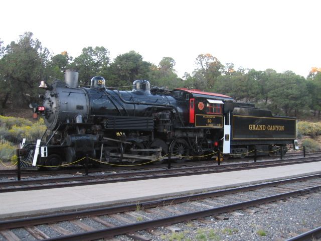
2014 visit to the Grand Canyon.   South Rim near the train station.


Add Reply

Post
×
×
×
×
Link copied to your clipboard.
×
×