I'm in the planning stages of a 3-rail layout focused on the San Francisco Bay area. My point of inspiration is the Ocean Shore Railroad- an ultimately unsuccessful railroad with the grand dream of running a railroad from San Francisco down the coast to Santa Cruz.
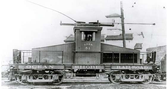
The Ocean Shore had pretty interesting operations on the San Francisco end of things. The tracks ran down busy streets and franchise restrictions required the use of electric locomotives in the city like this steeple cab.

However, for the run down the coast, the Ocean Shore primarily ran a fleet of Baldwin 2-6-0s and 2-6-2s like this Prairie at Half Moon Bay.

The change over from steam to electric was accomplished at a yard located on Army Street that also served as the shops for the line. At first, I only found this tantalizing photo, which didn't really give me much idea how the yard was configured.

Online resources only provided me with equally uninformative diagrams like this one. (the Army Street Shops are at E)

I started making better headway when I looked at historic street maps of the city, and I really hit paydirt when I found a high res image of the "Chevalier Commercial, Pictorial and Tourist Map of San Francisco" from 1912. I'll provide the link so you can check it out. The details of railroad trackage in the city are fascinating. http://www.mappery.com/map-of/...f-San-Francisco-1912
All the details of the Ocean Shore are shown here, including the Army Street Shops as can be seen in this detail.

This image clearly shows the yard tucked into a triangle between Bernal Heights to the west, Potrero Hill to the north and Islais Creek to the south. An interesting note is that the shops were built on marshland reclaimed by dumping rubble from the 1906 earthquake into the wetlands. The yard, then, is built within a wye junction with the eastern exit curving north to travel up Potrero Avenue to the Ocean Shore terminal at 12th and Mission, the eastern exit proceeding along Islias Creek, under the Southern Pacific mainline, to an interchange with the Western Pacific, and the southern exit curving down around Bernal Heights towards the coast and points south.
I knocked up a quick SCARM approximation of what I think the Chevalier map indicates.

Trains pulled by electric locomotives from the city would enter from top left and then head east along the top section of the wye. The electric locomotive would be uncoupled, and a steam engine would be backed down onto the opposite end of the string of cars for the trip south, effectively reversing the entire train.
Getting back to this picture-

I believe we are south of the shops, looking north towards Potrero Hill. The spur on my diagram that points directly north would go directly into the large shop building in the center left of this photo (if you look closely, I think you can see the open door where the track enters.
Anyway, I was pretty happy to have (hopefully) solved the puzzle of the Army Street Shops and figured if anyone would find it interesting, it would be you guys.
-S


